Deschutes River State Recreation Area – Ferry Springs Trail
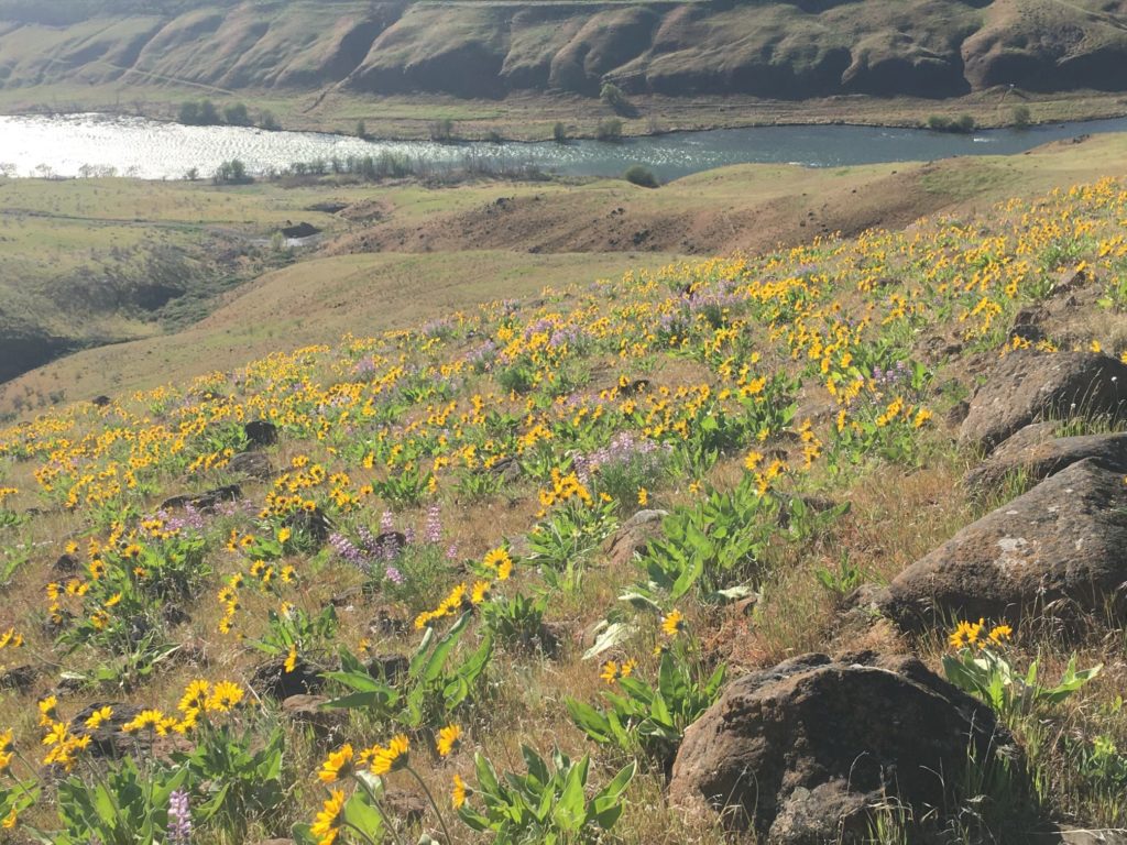
At the confluence of the Deschutes River and the Columbia, this loop hike ascends the sides of the river canyon to a plateau above the park with excellent views. In spring, wildflowers along the trail color the hillsides with patches of golden yellow, purple, and pink. Lupine, Shooting Stars, Balsam Root, Desert Parsley, and Paintbrush are most common along this route and others, like Showy Milkweed and Blanket flowers have also been spotted.
The Ferry Springs Trail Loop branches off from the Old Railbed Trail (gravel road) that begins at the parking area near the entrance. After crossing Ferry Springs, it descends back down to the Old Railbed Trail, and visitors can return via the gravel road or the blackberry trail that follows the river. This is a moderately-difficult hike, so be prepared with good shoes and some stamina for this 4.2-mile trip.
Access to the trail is from the Deschutes River State Recreation Area, near The Dalles. There is no day use fee. The park has a campground with 34 RV sites with water and electric. In the Spring, Summer, and Fall, tent camping loops are open as well – including group camping. Equestrian trail permits are available for Spring trail rides along the Deschutes River Trail.

Eight Dollar Mountain Boardwalk
The Eight-Dollar Mountain Botanical area is part of the Wild and Scenic Illinois River Corridor. The botanical wayside is easy to access from US199 (Redwood Highway) out of Grants Pass. The botanical area is found just off the highway, about 3 miles south of the town of Selma, and the parking area is well-signed.
A wheelchair-accessible boardwalk extends a third of a mile into a serpentine darlingtonia fen, recognized as a significant botanical site in Oregon. Along the boardwalk, visitors can see the darlingtonia blooming May and June, as well as asters and other wildflowers in this special place. The boardwalk is wheelchair-accessible and ADA-compliant restrooms are available at the parking area. There is no day use fee.
Several other nearby trails offer opportunities to further explore the region, and there are two first-come, first served campgrounds nearby (Little Falls Campground and Josephine Campground). Some areas may require a recreation pass, such as the NW Forest Pass or America the Beautiful pass.
Learn more about visiting here on the US Forest Service website or from the BLM brochure.
The Camassia Natural Area
Protected by the nature conservancy, this Camas meadow just south of Portland features the Common Camas, a native that is an important food in traditional Northwest Indigenous culture. In April, May and June, the Camas are flowering here along with over 400 other species of plants here.
The Camassia Natural Area is a 26-acre preserve with several short trails. The longest trail is a half-mile loop trail with interpretive signage along the route. While it is short, the mix of terrain and trail footings do pose challenges for mobility devices. Facilities are limited here, so be prepared to pack out any trash and note that there is limited parking and there are no restrooms on-site.
These limitations aside, this may be one of the few urban locations where one can see such an abundant display of wildflowers, so if you are in the Portland area and seeking a short escape, this protected oasis is worth a visit. To get here, take Sunset Avenue from Willamette Falls Drove and turn right on Walnut street; the park entrance is at the end of the street.
Cone Peak Meadows
There are multiple trails in this area and many have beautiful wildflower displays this time of year. The Cone Peak hike is a little less challenging than some, being just short of 5 miles out and back, with an 820-ft elevation gain. Over 300 species of wildflowers can be found along the trail, including many rare native species. Most commonly, a painter’s palette of purple, red, yellow and pink with larkspur, paintbrush, stonecrop, and penstemon, and coneflower.
Well-known to wildflower enthusiasts, Cone Peak is sometimes busy during the Spring, but it is still a relatively remote trek. The Tombstone Pass trailhead is about halfway between Sweet Home and Sisters, off the Santiam Highway. To get here, take Highway 20 to the Tombstone Sno-Park at Tombstone pass. Parking is at the Sno-park; $5 fee applies (recreation passes accepted include the America the Beautiful Pass and NW forest pass, among others).

Silver Falls State Park – Maple Ridge Trail
At Silver Falls State Park, the Maple Ridge trail is your best bet for seeing Spring wildflowers, with the most blooms occurring near the end of April. This trail is where one can see an abundance of woodland wildflowers, such as Fairy Slipper orchids, Pacific Bleeding Heart, Scouler’s Fumeroot, Western Trillium, Salmonberry, and Wood Violet.
The Maple Ridge Tail begins in the day-use area by the South Falls Nature Store, with a view of the falls from above. After following the paved path down and behind the South Falls, the trail continues on toward the lower South Falls. This popular trail is likely to be quite crowded this time of year, but less so if you venture the full 2.6 miles to the lower falls and back. The park will be hosting a birding and wildflower festival on May 7 and 8; check with Oregon State Parks for details.
Oregon State Parks has a guide to the wildflowers at Silver falls and a map for navigating trails.

Yes, we are blessed with awsome areas ! Thanks for the high lites , how about info for us DOG lovers who like to have ’em with us on our hikes ?
Nice idea, Ken. Thank you!
Thanks for listing some of the flowers that can been seen at these trails. I had no idea of a few of them, and that they could be seen here, and am ready to go looking for them!